
29182. (chart) EAST PENOBSCOT BAY (MAINE). 1882.
Welcome to Kenrick A. Claflin & Son
Featured on our web site and in our monthly web catalogues are new and out-of-print books, documents, post cards, photographs, maps and charts, engravings, lithographs, uniforms and insignia, tools, lamps, lens apparatus, equipment and apparatus and much more relating to these heroic services.
We now issue most of our catalogues on line rather than by mail. This allows us to issue more catalogues and feature more items, with better photos and descriptions. Let us know your email address and we will email you monthly as our catalogues are posted.
Type in your search word. After hitting Enter you will automatically be brought back to this page. Scroll down to this spot to see the results of search. Pages containing your search word will be listed. You will be allowed to click on the pages found. When on each page, Windows Explorer will allow you to use Ctrl + F to bring up a search box for that page. Type in your search word again and hit “Enter”. You will be taken to that item.

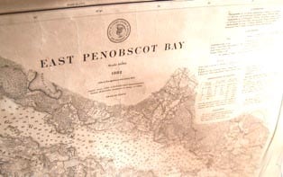
29182. (chart) EAST PENOBSCOT BAY (MAINE). 1882.
29182. (chart) EAST PENOBSCOT BAY (MAINE). 1882. U. S. Coast and Geodetic Survey. Scale 1/40,000. Lovely, very large 27 ½”w x 42” h original Coast Survey chart backed with linen details features of East Penobscot Bay from Saddleback Ledge and Isle Au Haut to Deer Island Thoroughfare, Deer Island, Eggemoggin Reach and Cape Rosier. Included on the chart are tides and currents for the area, soundings, a listing of Light-Houses. Light-Houses and buoys are denoted as are towns and features. This chart has been nicely mounted for use on two wood rollers, with linen tie and is in unusually good condition, overall clean and bright save one or two spots and a bit of light foxing, with only light wear to edges. Matted or not, this chart would certainly display impressively in a fine wood frame. Shipped rolled. Quite rare in this fine condition. (VG+). $285.