
33036. Maine Coastal Charts U.S.G.S. 1919-1948
Welcome to Kenrick A. Claflin & Son
Featured on our web site and in our monthly web catalogues are new and out-of-print books, documents, post cards, photographs, maps and charts, engravings, lithographs, uniforms and insignia, tools, lamps, lens apparatus, equipment and apparatus and much more relating to these heroic services.
We now issue most of our catalogues on line rather than by mail. This allows us to issue more catalogues and feature more items, with better photos and descriptions. Let us know your email address and we will email you monthly as our catalogues are posted.
Type in your search word. After hitting Enter you will automatically be brought back to this page. Scroll down to this spot to see the results of search. Pages containing your search word will be listed. You will be allowed to click on the pages found. When on each page, Windows Explorer will allow you to use Ctrl + F to bring up a search box for that page. Type in your search word again and hit “Enter”. You will be taken to that item.


33036. Maine Coastal Charts U.S.G.S. 1919-1948
New England Coastal Charts
Decorate Your Wall With An Original Vintage Nautical Chart Of Your Favorite New England Coastal Area.
We have discovered a wonderful selection of vintage c. 1919-1948 U.S.G.S. coastal navigation charts covering the coast of Maine. These charts are quite large and are generally little or unused, most with only one or two original folds. They are quite large, overall clean and bright and would be a perfect choice for framing to mount on your wall. As expected, each includes excellent detail of Coast Guard stations, coastal navigational aids including lighthouses, lightships, and much more. All in VG or better condition, few marks unless noted. We have 35 charts available. #33036.
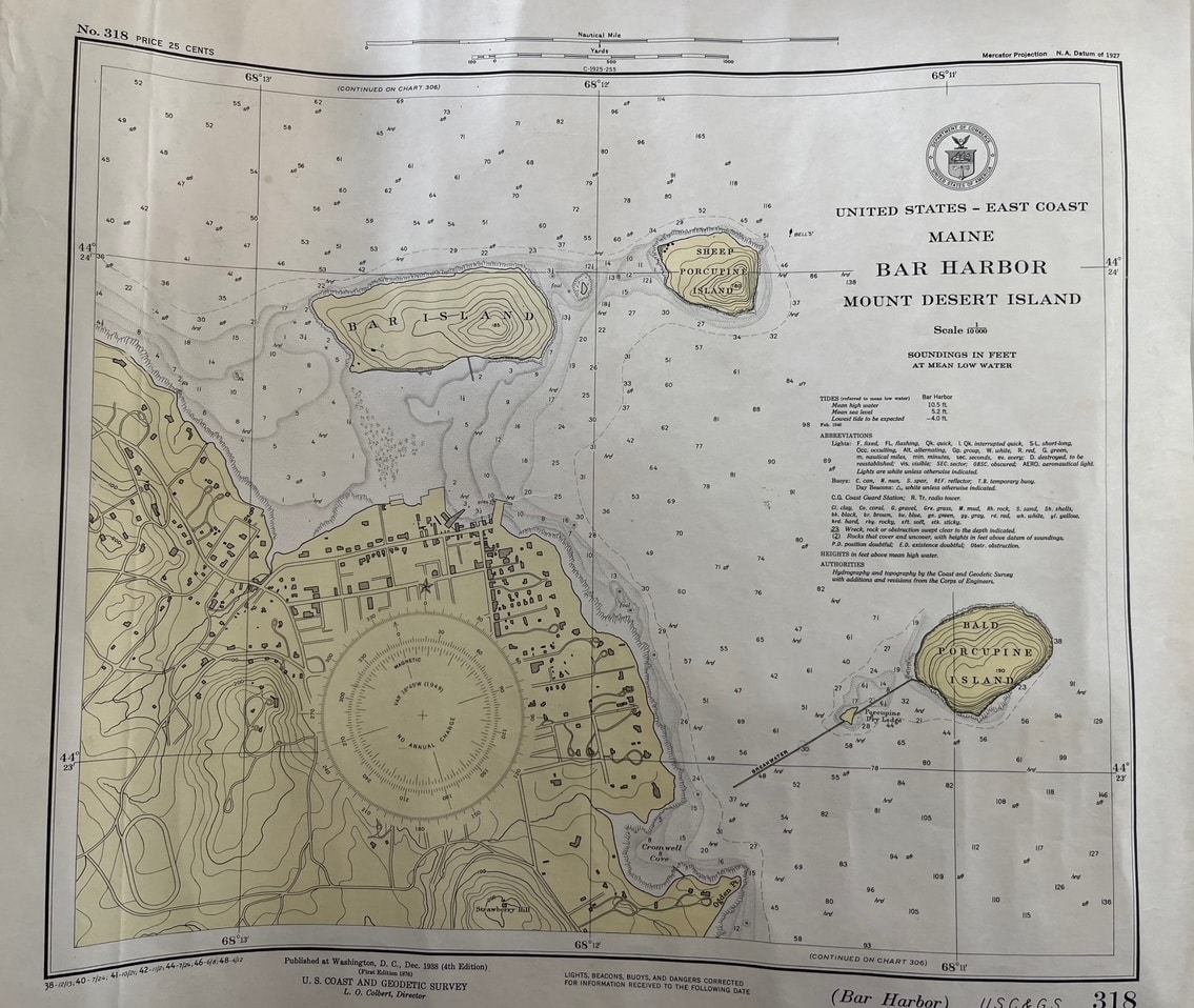
- Bar Harbor Mount Desert Island. 1938. (16 ½” x 17 ½”). Bar Harbor, Bar Island, Porcupine Islands. $16.
- Kennebec and Sheepscot Rivers. 1938. (41” x 26”). Damriscove to Cape Small. $20.
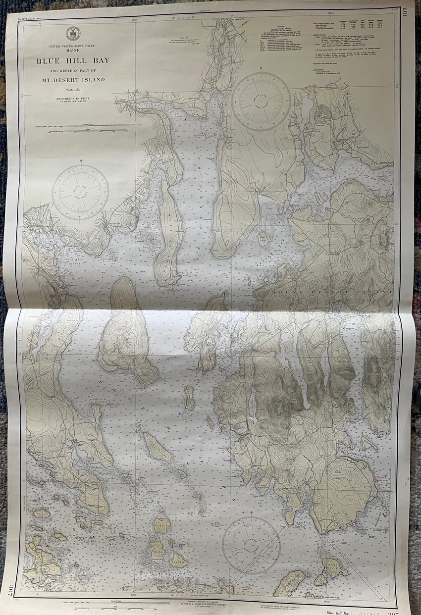
- Blue Hill Bay and Westerly Part of Desert Island. 1943. (42” x 27”) Bass Harbor Head to Blue Hill Neck. $24.
- Blue Hill Bay and Eggemoggin Reach. 1942. (40” x 28”). Baker Island to Isle Au Haut. $22.
- East Penobscot Bay. 1943. (42” x 27”) Herrick Bay to Vinalhaven. $22.
- Nash to Schoodic Island. 1939 (41” x 27 ½”) Shows Columbia Falls, Addison, Harrington, Cherryfield, Millbridge, including Prospect Harbor light, Nash Is., Petit Manan Is., etc. $22.
- Frenchman Bay & E. Part Desert Is. 1942 (42” x 28”) From Schoodic Peninsula to Bass Harbor Head. Bar Harbor and Winter Harbor shoreline shown. Baker Is. Lt., Bass Harbor Lt., Egg Rock Lt. Shown, etc. $22
- George River and Muscle Ridge Channel. 1946. (40” x 28”). From Owls Head to Monhegan Island. $22.
- West Penobscot Bay. 1938. (41” x 27”) From Vinalhaven to Sprucehead Island. $22.
Decorate Your Wall With An Original Vintage Nautical Chart Of Your Favorite New England Coastal Area.
A-139 More Maine Charts
- Quoddy Roads to Petit Manan Is. 1941 (42 ½ X 32 ½). Grand Manan Island, etc. $24.
- Cross Is. To Nash Is. 1943 (41 x 29) Nash Is. Lt., Moose Peak Lt., Libby Is., Avery Rock Lt. Shows many islands and details of shoreline, etc. $24.
- Nash to Schoodic Is. 1939 (27 ½ x 41) Shows Columbia Falls, Addison, Harrington, Cherryfield, Millbridge, including Prospect
Harbor light, Nash Is., Petit Manan Is., etc. $24. - Blue Hill Bay 1943 (27 1/2X 42 ½). Desert Island, western part, etc. $28.
- Moose Cove to Englishman Bay 1919 (41 X 29 ½)./ Machias Bay, Cross Island, etc. $24.
- Deer Is. Thoroughfare & Casco Passage 1938 (35 x 22) Mark Is., Stonington, Parts of Swans Is., etc. $24.